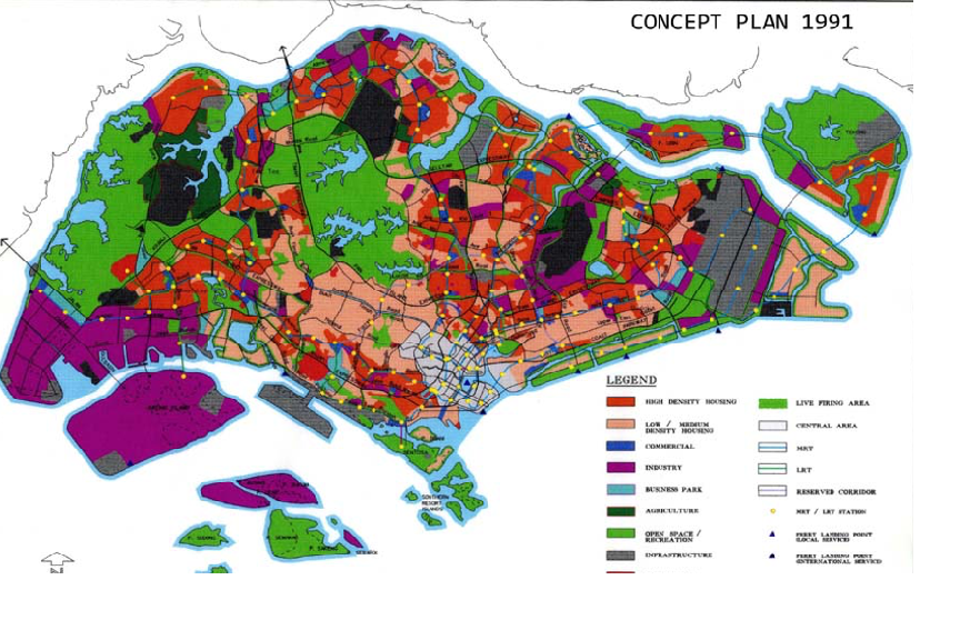
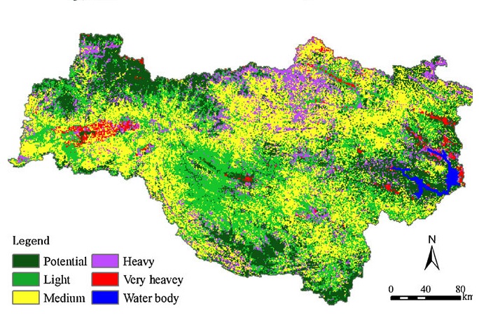
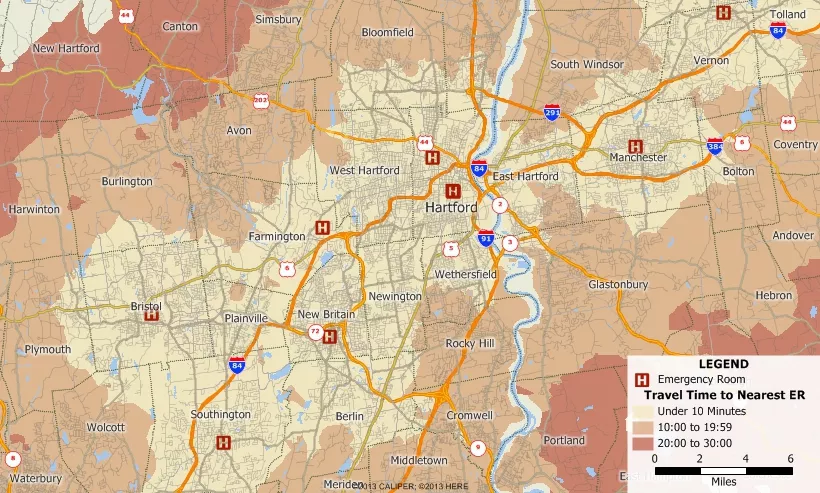
+91 9246163747 (India)
+1 804 610 1380 (USA)
WhatsApp Icon Video

Mapdrafter

Mapdrafter Overview

ACTCAD Map Drafter is a specialized CAD software meticulously designed for cartography and map drafting needs. Offering a seamless blend of intuitive tools and precision drafting features, Map Drafter enables users to create intricate maps with ease. With its user-friendly interface and comprehensive set of drawing tools, professionals and enthusiasts alike can produce high-quality maps for various purposes. Its compatibility with popular file formats ensures smooth collaboration and seamless integration with existing workflows. Backed by regular updates and dedicated technical support, ACTCAD Map Drafter stands as a reliable solution for map creation, catering to the diverse needs of cartographers, urban planners, architects, and GIS professionals worldwide.

Image


Highlights

Icon 1

Cartography Focus:ActCAD Map Drafter is specifically tailored for cartography and map drafting tasks, ensuring precision and accuracy in map creation.

Icon 2

Intuitive Tools: The software provides a wide range of intuitive tools designed to streamline the map drafting process, making it accessible for both beginners and experienced professionals.

Icon 2

Compatibility: It is compatible with various file formats commonly used in the industry, allowing seamless integration with existing workflows and collaboration with other software applications.

Icon 2

Technical Support: Users of ActCAD Map Drafter benefit from dedicated technical support to assist with any questions, troubleshooting, or guidance needed during the map drafting process.

Features

Feature 1

Latest IntelliCAD 12.1 Engine

The latest IntelliCAD 12.1 Engine offers improved performance, stability, and compatibility with DWG/DXF formats, along with new features and enhancements for a smoother CAD experience..

Feature 2

FIND GAPS

"GAPSFIND" command aids in quality control and accuracy by assisting users in identifying and resolving any discontinuities or gaps in polyline objects within their CAD drawings.

Feature 2

FIND OVERLAPS

identify instances where one polyline overlaps another polyline within a drawing.This functionality is particularly useful in CAD environments where accurate geometry is crucial.

Feature 2

Latest ODA 23.12 DWG and DXF Libraries

Latest ODA 23.12 DWG and DXF Libraries,Utilize the latest ODA libraries to ensure compatibility and seamless integration with industry-standard DWG and DXF formats.

Feature 2

New SUPERHATCH command to create hatches using images, textures, blocks, external references

The SUPERHATCH command in ActCAD introduces a versatile way to create hatches by incorporating images, textures, blocks, and external references.

Feature 2

Create reports and report templates, extract data to tables and .xls files

Users can extract data from their drawings and organize it into tables, which can then be exported to both standard table formats and .xls files, providing flexibility in data management and analysis.

Feature 2

FLOW DIRECTION

"FLOW DIRECTION" tool is typically used in GIS (Geographic Information Systems) applications for analyzing the direction of flow in a surface, such as water flow in a terrain model or drainage analysis.

Feature 2

MAP PDF

It export of map drawings or layouts to PDF format, providing a convenient way to share or distribute map data and designs in a universally accessible and printable format..

Feature 2

SHAPE EXPORT

It allows users to export selected shapes or entities from their drawing to other formats compatible with various software applications, facilitating interoperability and collaboration in design.

Feature 2

IMAGE CALIBRATE

It allows precise scaling and alignment of raster images by assigning real-world coordinates to known reference points, ensuring accurate integration with the drawing's coordinate system for mapping tasks.

Feature 2

IMAGE BOUNDARY

"Image Boundary" refers to the perimeter or outline of a raster image or scanned map within the drawing environment. This boundary delineates the extent of the image and is often used for spatial reference and analysis in mapping applications.

Feature 2

IMAGE EXPORT

ActCAD Mapdrafter allows users to accurately scale and align raster images or scanned maps within their drawing environment. This process involves specifying known reference points on the image and assigning corresponding real-world coordinates to them.

Feature 2

MAP NUMBER SERIES

sequential numbering system applied to map features or elements within a drawing. This numbering scheme helps organize and identify different components of the map, facilitating data management.

Feature 2

MAP NUMBER COUNT

enumerates the total number of map elements or features within a specified area or category. This count provides quantitative information about the distribution and density of map data

Feature 2

MAP DIRECTION

It indicates the direction in which features are positioned relative to a reference point or axis, aiding in navigation, analysis, and interpretation of spatial data.

Feature 2

MAP MARKERS

In Mapdrafter, "Map Markers" are symbols or feas used to represent specific points of interest, locations, or features within a map drawing.

Feature 2

New ANGLE command

The ANGLE command in ActCAD allows users to specify precise angles for drawing and editing objects, facilitating accurate geometric constructions and transformations within the CAD environment.

Feature 2

MAPCLEAN

optimizes map data by removing duplicates, simplifying geometry, and correcting topology issues, ensuring high-quality and organized geographic datasets.

Feature 2

4 Point Image Rectification

It allows users to accurately scale and align raster images or scanned maps within their drawing environment by identifying known reference points and assigning corresponding real-world coordinates, ensuring precise integration of images with the drawing's coordinate system.

    
Feature 2

CENTROID

"Centroid" refers to the geometric center point of a polygonal feature within a map drawing. It represents the average position of all the points defining the polygon's boundary and is commonly used for spatial analysis, labeling, or as a reference point in GIS

Add-ons


ACTCAD Convertor

ActCAD Standard provides comprehensive 2D drafting tools for creating precise technical drawings and schematics.

PDF to DXF Convertor:

Users can create and modify 3D models with ease, enabling visualization and simulation of designs.

Raster to Vector

ActCAD Standard supports industry-standard DWG and DXF file formats, ensuring seamless compatibility with other CAD software.

Block Library:

Efficiently manage drawing elements by organizing them into layers, allowing for better control and organization.

Unit Convertor:

Create and manage reusable blocks and attributes to streamline the design process and maintain consistency across drawings.

License Transfer:

ActCAD Standard offers a variety of dimensioning tools for accurately measuring and annotating drawings.

PCD Import:

Customize the workspace, toolbars, and shortcuts to suit individual preferences and workflows.

Open PDF and Edit

Benefit from productivity-enhancing addonss such as snap tools, grips, and dynamic input for faster and more efficient drawing creation.

Calculator

ActCAD Standard is available for both Windows and macOS platforms, allowing users to work seamlessly across different operating systems.

Annotation and Markup:

Annotate drawings with text, dimensions, and symbols, and mark up designs with comments and revisions.

Block Library:

block library is a collection of pre-defined geometric shapes, symbols, or objects that can be reused in drawings. These objects are often grouped together and saved as a single entity, known as a block.

Printing and Plotting:

Print or plot drawings to scale, with options for customizing paper size, layout, and output settings.

Who used?

  1. Architects
  2. Urban Planners
  3. Civil Engineers
  4. Landscape Architects
  5. Surveyors
  6. Environmental Scientists
  7. Geographic Information System (GIS) Analysts

Why used?

  1. Affordable: ActCAD Mapdrafter offers a cost-effective solution for creating maps and drafting designs compared to other CAD software in the market.
  2. Feature-Rich: It provides a wide range of features specifically tailored for map drafting, including GIS functionalities, terrain modeling, and spatial analysis tools.
  3. Intuitive Interface: The software is designed with a user-friendly interface, making it accessible to beginners while still offering advanced tools for experienced users.
  4. Compatibility: ActCAD Mapdrafter is compatible with industry-standard file formats such as DWG, DXF, and SHP, ensuring seamless integration with existing workflows and compatibility with other CAD software.

Contact Us

Feel free to contact us for any inquiries.

Licensing Types

Explore our various licensing options.

Applications

Advantage 1

Urban Planning

Advantage 2

Land Surveying

Advantage 3

Environmental Mapping

Advantage 4

Emergency Response

Advantage 5

Navigation Systems

Advantage 6

Infrastructure Development

videos


Free Trial Without Limitations